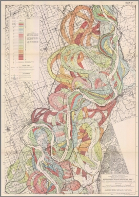
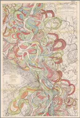
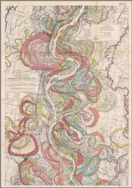
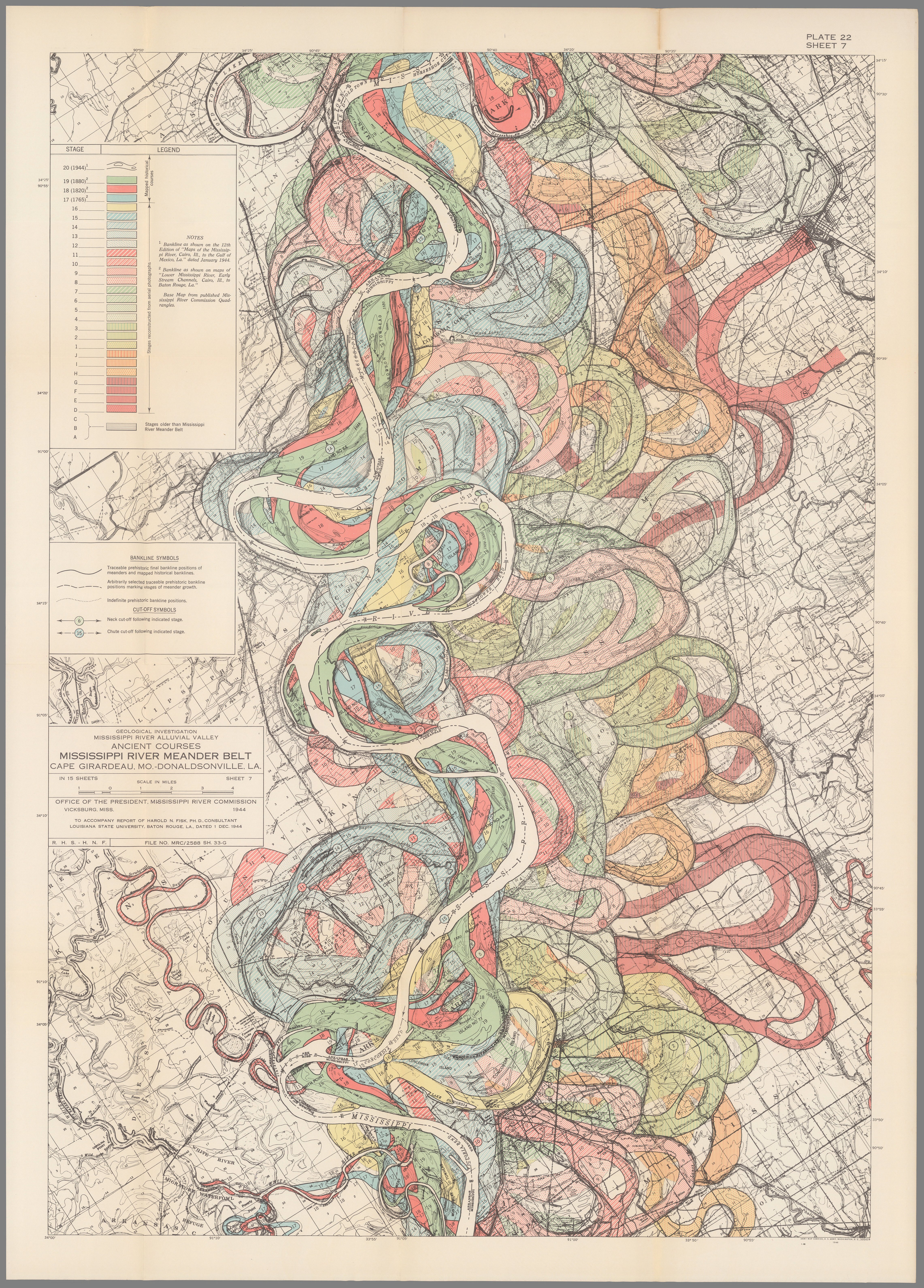
There is a well-known historic map that often appears in art books and online forums as a beautiful example of what might otherwise be a dry topic: the Geological Investigation of the Alluvial Valley of the Lower Mississippi River, published by Harold Fisk for the U.S. Army Corps of Engineers in 1944. The maps that accompany the report show the Mississippi meander belt with overlapping colors and lines, and drive home the point that rivers are ever-changing entities and maps are a form of art.
Like so many others, I’ve always admired the Mississippi meander maps produced by Harold Fisk. And like most cartographers, I’ve always wondered how I could make a similar map.
This winter I created my own river meander map to mimic Fisk’s work. My goal with this map project was two-fold: First, to faithfully reproduce a map that from a distance appears to be part of the Fisk series, and second, to create an ArcGIS Pro style for others to do the same with their own data. You can download the map here or the style here and read on for details of the process.

Why the Koyukuk River?
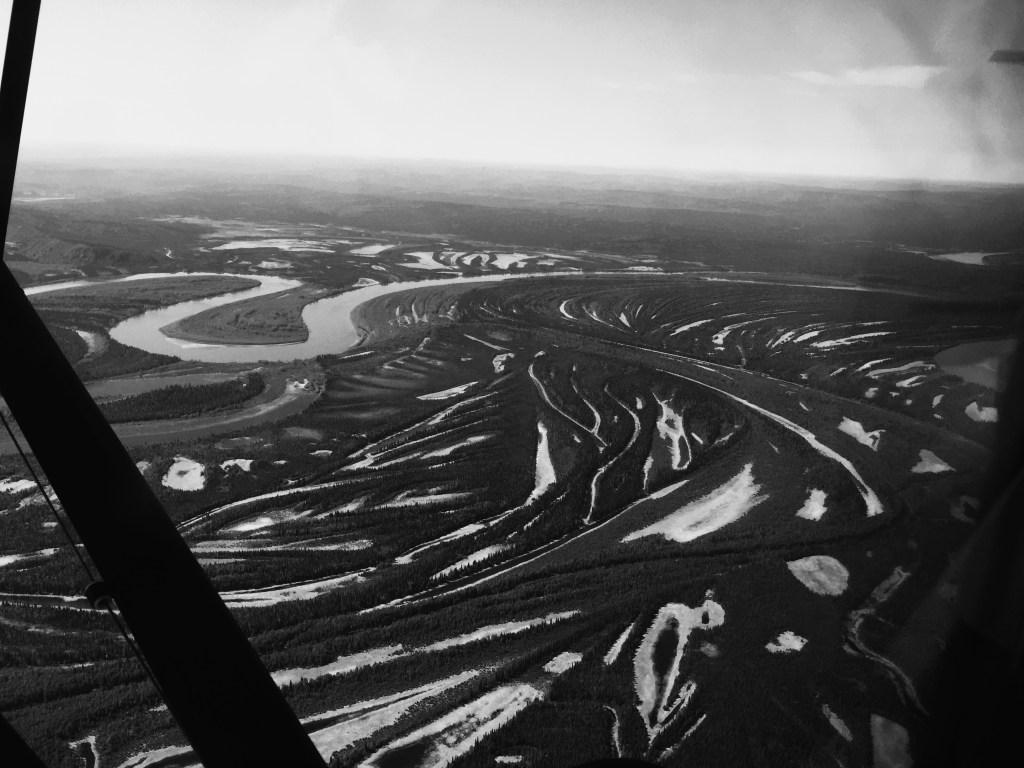
As I’ve said before, I want to put Alaska on the map and I’ve long looked to the Koyukuk River as the archetype of a meandering Alaskan river. Additionally, the area always seems to be the center of excitement, perhaps from the presence of so many famous Native Alaskans: Eliza Jones (linguist), Catherine Attla (elder), George Attla and Jimmy Huntington (mushers), and John Sackett (legislator), to name a few.
However, other than a few overflights, most of what I know about the area and the culture I have learned from books, with two of my favorite books taking place along the river: “Shadows of the Koyukuk” by Sydney Huntington and “Make Prayers to the Raven” by Richard Nelson.
Due to the area’s aesthetics and the weight of history in the area, I was drawn towards seeking out datasets in the Koyukuk River area that could be used to mimic the Mississippi Meander maps.
River Deposits
As luck would have it, I stumbled upon a research article published a few years ago that included a geospatial dataset of floodplain chronosequences and prior river channels. The intent of the research was to determine where permafrost was located in the river valley and estimate how long it took for permafrost to form in those areas, as well as whether the type of vegetation and age of the surrounding soil affected permafrost formation (Morris, et. al., 2023)1
To map the relative age of the floodplain deposits in GIS, the researchers used the theory of cross-cutting, where any deposit that crosses over another deposit must be younger than the deposit it crosses over. Mapping river deposit age is still mostly a manual process, done by hydrologists and geomorphologists, and although the cross-cutting theory is quite old, Fisk’s work on the Mississippi in the 1940’s is one of the best known applications using river meanders.
Tla-dzor-karas’ana: sp ro to korõkeltl. (nu)
Riddle me: The river is tearing away things about me. (An island).
-Denaakk’e (Koyukon Athabaskan) riddle, Jette (1913)2
Place Names
There is a lot of black ink in Fisk’s map due to the prodigious amount of development along the Mississippi, including place names, roads, railroads, farms, etc. Although the Koyukuk River valley is not nearly as densely populated as the Mississippi River basin, this doesn’t mean the landscape is devoid of life. The Koyukon people have been, are currently, and will continue to be stewards of this land, and their familiarity with the area helps bring it to life on a map.
To prove this point, I’ve pulled in data that was collected for a project that mapped Koyukon Athabaskan (Dene) place names along the Koyukuk River (McCloskey and Jones, 2014)3. This project, in addition to documenting place names, brought together elders and youth who were transported to the landmarks to share stories and knowledge. Currently, Denaakk’e (the Koyukon Athabaskan language) is only spoken fluently by about 150 people, many of whom are elderly. Languages are not only a means of communicating needs but also communicating culture and values, so the preservation of threatened languages through passage to younger generations is vital to maintain tribes. If you are interested in learning Alaska Native languages, check out the Doyon Foundation’s Language Revitalization Program for free, self-paced classes.

Style
I created an ArcGIS Pro style file based on Fisk’s map, with some building blocks from various style files initially created by Warren Davison and colors extracted from Fisk’s map.
To imitate the text from Fisk’s map, I referred to the USGS Topographic Map Standards from 1928. For the fonts, I chose the following:

General
Halfway through creating this map, I noticed a bug in ArcPro that causes it to crash when more than 3 layers are labeled with a picture polygon fill. Unfortunately, because this map was created with my Personal Use license, I can’t file a case with Esri. Therefore I had to create many annotation files instead of using labels.
Additionally, because of the new ArcGIS personal use terms, I have lost the use of the Cartography toolbox that would allow feature masking for the annotation and contours. However, I decided to maintain the crowded look so as to better mimic Fisk’s work (or at least maintain this look until I upgrade to an Adobe Illustrator workflow!).
I’m looking forward to seeing how others apply the style to their own work. Share your maps with me on LinkedIn: http://www.linkedin.com/in/britta-schroeder
- Douglas, M. M., Li, G. K., West, A. J., Ke, Y., Rowland, J. C., Brown, N., et al. (2024). Permafrost formation in a meandering river floodplain. AGU Advances, 5, e2024AV001175. https://doi.org/10.1029/2024AV001175 ↩︎
- Jetté, Julius. “Riddles of the Ten’a Indians (Concluded).” Anthropos, vol. 8, no. 4/5, 1913, pp. 630–51. JSTOR, http://www.jstor.org/stable/40443930. Accessed 11 Jan. 2026. ↩︎
- McCloskey, S. E., & Jones, B. (2014). Mapping traditional place names along the Koyukuk River: Koyukuk, Huslia, and Hughes, Western Interior Alaska (Report Nos. 2014–3105; Fact Sheet, p. 2). USGS Publications Warehouse. https://doi.org/10.3133/fs20143105
↩︎

You must be logged in to post a comment.